Like many another American town, Lancaster finds its origin in an Indian trading post. Although no contemporary mention appears of this, the first mercantile enterprise on Lancaster soil, it must have been founded before the autumn of 1643. Whether it preceded, or was subsequent to, the purchase of eighty square miles of land from Sholan, cannot be told. Both Symonds and King so soon disappear from the scene that they have been commonly treated in our history as mere real estate dealers, who sold their bargain at the first advantageous offer. Is there not in the scanty facts which follow, heretofore ignored, something that suggests rather trouble, sickness and disappointment, than the harvesting of profit?
Here it is my best guess at where the Old Lancaster Road ran during King Philips War.
There was only one road from from Sudbury to Lancaster
There were only two Homesteads in Stow – Boon and Kettle
There may have been one Homestead or Garrsion in Bolton – Moore
Otherwise the Kettles and anyone else living in Bolton would have had to go all the way to the Rowlandson Garrison House in the old center of Lancaster west of the river.
Hi Petrus
Glad to see you’re back, did you get home to Peru over the holidays?
I see on your map you have some dotted lines what are those?
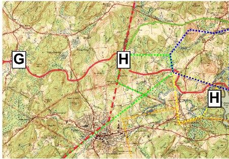
The dotted lines are an attempt to visualize where the grants made in the 1650’s were laid out and how these lead to the Town Boundaries we have now.
Blue – Willard
Yellow – Alcock
Orange – Agaganamessett
Green – Walcott / Bush? / Kettle?
Red – Original Lancaster/Marlboro Bound
Walnut Swamp or Cedar Swamp
If the Kettles rented a farm from Joslin was it on Long Hill ?
They would have wanted to be close enough to the Grant bought from Deputy Gov. Symonds to work it.
What color is the Symonds Grant on your map?
Is this the same Symonds as the Trucking House?
I am currently trying to reconcile the Ordering of Towns and the butts and bounds of the original survey/grants.
Per Marvin – Lancaster’s orientation 1 degree from North
Per Payne – Line from Harvard Sq to Meeting of the Rivers Lancaster ~20 degrees
Current Bolton Stow Bound 19.5 degrees
Symonds grant ran 4 degrees north of north east ~40 degrees
The Pentagon and Marlboro West Bound ~56 degrees
Was Noyes using a compass when he surveyed the Lancaster/Marlboro and the symonds grant in the 1650’s
Or did he only survey on the equinox so he could ascertain true east/west
The difference between Magnetic and True North currently -15.5 degrees and accelerating.
Historically it was less, quoted as -5 degrees around the revolution.
It may have been insignificant in 1650
My markups are made on top of the 1943 Topo Map containing surveys from 1923 and 1941.
The red line is the 1656 Lancaster Road
The green line is the 1656 Concord Road
The Deputy Govenor was Samuel Symonds
In 1645 he became a member of a free company of adventurers who received permission from Massachusetts authorities to operate a series of trading posts under a 20-year monopoly.
Henry Symonds, was the senior partner and capitalist of the Nashaway trucking house
Henry died 1643 in Boston
These guys must be related. How many Symonds could there have been between Boston and Lancaster in the 1640’s?
Looks like Samuel picked up in 1645 where Henry left off in 1643
I count seven before 1660
Wow that Ordering of Towns is fascinating
Did you know Lancaster was laid out on a direct line from the meeting of the rivers back to Harvard Square?
Also interesting is that Cambridge St and the grid in East Cambridge are aligned on this same axis
Looks like it is a direct line to the Registry of Deeds
Who wants to take a drive down 117? We’ve got quite a few deeds to look up.
We can only get back to 1900 online – if you know the Book and Page
otherwise you can only search back to 1960
The county [Middlesex] was created by the Massachusetts General Court on May 10, 1643, when it was ordered that “the whole plantation within this jurisdiction be divided into four shires.” Middlesex initially contained Charlestown, Cambridge, Watertown, Sudbury, Concord, Woburn, Medford, Wayland, and Reading.[5] In 1649 the first Middlesex County Registry of Deeds was created in Cambridge.
And as a special treat you can do an unindexed search on the first 13 “bookes”
First Deed 1648 in Watertown
Willard and Alcock were both also involved with the indians.
“He [Willard] was employed by the government in various transactions with the Indians, and was associated with Apostle Eliot, and Major Gookins, in their friendly missions. When a company was formed to encourage the trade in furs with the Indians, he was intrusted with the superintendence…..Major Willard received a number of grants of land, making in all between four and five thousand acres, exclusive of this right to subsequent divisions in the lands of Lancaster. The towns of Acton, Stow, and a part of Groton, are on land that belonged to him…….
the court appointed Lt. Willard, and others giving them the freedom “to trade with the Indians all manner of commodities, except guns, powder, shot & weapons”…….“Before his death, he was to serve as commander in chief of the Colony’s forces in the Indian trouble. Yet unlike many Puritan leaders, he was no bigoted despiser of the red men. His fortune in the fur trade grew from his knowledge of how to handle Indians….
Alcock was a medical doctor:
“the Honourable Robert Boyle, Esquire, Governor of the Corporation for the propagation of the gospel in New England,” dated at Boston, 10 September, 1662, …. “To Mr. John Alkock, for physick to sick Indian scholars, pr. order, £y. 9. 5.”
Petrus,
I just posted your other maps and research, boy that’s a lot of work you’ve done.
https://nashawaytrailalpacas.com/wp-content/uploads/Old_Roads_and_Bounds.pdf
https://nashawaytrailalpacas.com/wp-content/uploads/Topo_1675.pdf
https://nashawaytrailalpacas.com/wp-content/uploads/Topo_1738.pd
https://nashawaytrailalpacas.com/wp-content/uploads/Topo_1794.pdf