Old Bay Road does not appear to make it all the way to the bay any longer. What Bay you ask. Well the Massachussetts Bay, you know that’s why we are known as the Bay State.
Back in the Day we were not all that creative with street names, in fact street names and especially street numbers are a fairly modern invention.
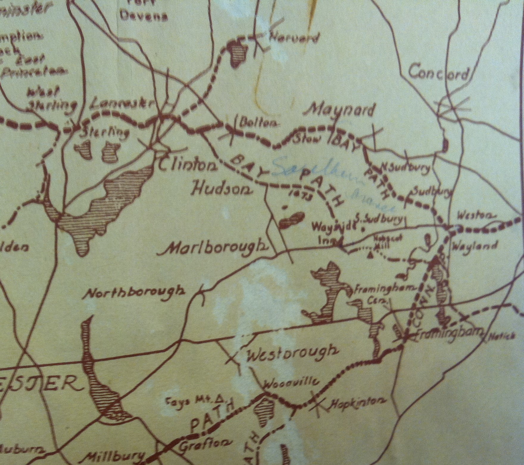
In 1673 the roads were named for where they went. Lancaster Road, Concord Road, Marlboro Road, and the really important ones were know as paths. The name a road went into town with was not necessarily the name it left town with. That’s why you see major roads that are obviously contiguous change name at the town-line. Paths on the other hand might be colony-wide, like the Old Connecticut Path or one of the many Bay Paths. Most of the Mother Towns like Lancaster had a Bay Path that lead back to Boston like the Hub of a Wheel.
Did the Natives consider Boston the Hub of the Universe too?
What is the importance of 1673?


These Bay Paths were laid out prior to King Philips War in 1673
These Paths were also laid out prior to the 1691 Marlboro Road
And the Marlboro Men’s the 1700 Road to the Mill
And the 1769 Maple Street now Manning Street
And it was way way before this map was drawn by Marlow in 1942
Instead of going by Lake Boon this Bay Path drops all the way down to the Way Side Inn at Route 20 near the Marlboro Sudbury Line.
Were the Native Trails know as Paths?
They look like they go to all the same places
Like when the Governor went to Lancaster in 1643
I think the white men just renamed the Indian Paths
Jasper
The Connecticut Path and the Nashaway Trail were definitely Native. They were part of infrastructure the English settlers inherited after the plague of 1617-1619 wiped out 90% of the native population in eastern Massachusetts.
However these new settlers made improvements over the years, Both widening and straightening the existing native paths until they could support a team of oxen and wagon carrying four barrels of cider
But over time as new homes and towns were built new roads were built and old roads rerouted to better suit the new inhabitants.
I think there may be clues in Norses book The early records of Lancaster, Massachusetts. 1643-1725
I read that book. It looks like Joslin had a house at Long Hill and it was on the country road and a new road was being created at the same time in 1670
“alowance to abra. Joslin for a highway.
Munday 3 0 : 11 : mon 1670.
The towns men meet at maior Willards house and ordered to alow Abram Josllin for a highway taken out of his land at longhill, Lying by his house to the medowes at Longhill, and alsoe the Cuntrie way, And he is to haue two acres for one and Ralph Houghton is to Lay it out as speedily as may be.”
1656 Concord Road
Thence it followed very nearly the present line of road to the wading place about one hundred rods below the meeting of the rivers, and proceeded due east over Wataquadock, along the now nearly disused way, formerly known as the ” Bay path,” or “Sudbury road.”
1659 Second Division of Meadow
“And then to begin at the north end of goodman Whellers medow and Lay out what is medow fit to mow towards master Josllins house and the medow by the baypath on the west sid the Long Hill and soe to a medow east sid the Long Hill. And soe to the medow that shuts vp to the baypath from Wataquadoke to begin at that end next to the baypath”
The early records of Lancaster, Massachusetts. 1643-1725
“T H E LANDS OF J E R E M I A H WILLSON
he hath a a peice of Land Laid out on the top of Wataquadoke hill on the north side the Countrie highway to Marlbrough buting South on the sd way and north on sum Land of Nathaniel Joslin Joyning to his southwest Corner marke and east and west it is bounded by plain Common Land and is Laid outfor nine acres and half be it more or Less: and was Laid out by John Houghton all the sd three peices of Land are Laid out for his full due for his thirty acre Lott be it more or Less :—
[Recorded 1690.]”
“THE LANDS OF JOSIAH WHEELER
T h e Lands of Josiah Wheeler Granted him by the town being his 30 acre L o t t a n d other deuision : there is Laid out to the sd Josiah Wheeler twenty three acres of his first Lott Lying whear he first built not far from the hogswamp his house Standing near the middle of sd Land . . . .and buts on Marlbrough path the east Line part of it Runs ouer a Rockey hill and takes in a Long pine Swamp at that side and a little aboue the house the Line turns with a short Crook and so Runs up to Marlbrough path this peice 23 acres more he hath seuen acres Laid out upon the brook that Runs from hogSwamp meadows to Spectacle meadow near whare sd Brook Corns out of the hogSwamp meadows and Lyeth mostly on the north side of the Brook . . . . both peices is Laid out for his first thirty acres Granted him by the Town Read the 5 t h : of february 1699/ 10 in order to be Recorded :—”
This indicates Spectacle Hill Road as the 1700 road to the Marlboro Mills
“The Return of one of said Hiwaies Lancaster June ye first &
26 1722.
Where as we the subscribers namely John Wilder Josiah White
and Ephriam Wilder are a Committy to vew and Lay out a hiway from Jonath Moors to Hogswamp medowes we haue bin upon the spot the dayes aboue dated and proseeded as followeth we began at said hogswamp medow and marked trees on the west side of said way to sd moorses; we Ran through the Land of Josiah Wheelor fourty Rods through the Land of Jonathan Moors three hundred and fourty Rods and through the Land of Jabaz fairbanks one hundred Rods and in the Land of John moors two Rods the other part of said Hiway Lyeth in Common Land the Committy JOHNWILDER JOSIAH WHITE EPHRIAM WILDER said ways was Exsept to be three Rods wide Exsept where it Cross ye medow of Jabez fairbank and there to be one Rod and half”
“Those in John Moore’s garrison lived on the Marlborough road in the southeast part of Bolton, near the district now called Fryville. The graves of the brothers John and Jonathan Moore are in the burial ground on the old road to Hudson”
Hog Swamp and Hog Brook are near the intersection of 495 and 62
Was the Marlboro Road Spectacle Hill or Berlin Road to Quaker/Sawyer
According to the Marlow Map above the Bay Path heads south, west of Bolton Center so it could not be Long Hill Road.
Something still does not add up.
I think Marlow has fallen for that old “New” vs “Old” Lancaster Road trick.
The North Bay Path on his 1942 map was pre-Phillip and would not have passed though either Stow or Bolton center.
After leaving 5 Corners the north branch could have traveled Forbush Mill to Green to Golden Run to Burnham to Long Hill
Or it could have followed the existing path the Sudbury Road (Old Lancaster Road)
“January ye 18th 1724/5 Marked out a hiway for the Conveniance of Samuell Rugg to Com to the Contery Road and it began at a white oak about ten Rods from the norwest angle of his Land which was Laid out for his Father on the northerly side and Runs northerly a Cross the Land of Jonathan Moors Seventy one Rods then it Run a Cross sum of the Land of John Moor twenty six Rods and Corns in to the bay Road at the edge of the plain neer a little Brook where the way has bin diged Easterly from the pond brook Called westpond brook JAMES KEYES JOSEPH SAWYER Committy this hiway was ConfermecJ by a vote, and then the meeting was ajorned to the first Monday in March next”
This sounds like the 1725 Annie Moore Road
1691. Simon Davis & Ensign Humphrey Barrett of Concord, John Howton & Nath” Wilder of Lancaster & Boaz Brown & Thomas Williams of Stow, are by this Court appointed a Comittee to lay out a convenien- high way from Concord according to Law, for theire direction in the matter, and to make theire report to y’ next Inferior Court for y” County of Midd*. [Middlesex Court Records.]
Early records of Lancaster