Who were the first to settle or build in the territory that would become Bolton?
The list will Include: Bush, Bruce, Houghton, Moore, Sawyer, Wheeler, Whitcomb, and Whitney, but did they have boots on the ground?
Who was A. M. Teele?
What’s this about Kettle and Joslin?
Where’s this Walnut Swamp?
Why would Kettle go nearly 10 miles from his home in the Wilderness (Now Stow or was it?) to Lancaster.
Marlboro would have been closer and away from the native attacks
Was kettle related or connected to the Joslins in some way?
Mrs Kettle was an Allen I believe both came from Salem
Here are the garrisons as of 1704
On ye east side of ye River
John Moore & Jonathan Moore
Allowed a Garrison:
John Moore Comander
Jonathan Moore
Will’m Sawyer
Joseph Sawyer
Josiah Wheeler
John Hinds
James Keyes
Those in John Moore’s garrison lived on the Marlborough road in the southeast part of Bolton, near the district now called Fryville. The graves of the brothers John and Jonathan Moore are in the burial ground on the old road to Hudson
John Whetcomb Sen. allowed a
Garrison
John Whetcomb Comander
Josiah Whetcomb Jun’r
David Whetcomb
Hezekiah Whetcomb
Jacob Houghton
Henry Houghton
John Wilder Jun’r
Those composing the Whitcomb Garrison lived also in Bolton, toward the northeast corner. Families descended from them resided there until recently. This is believed to be the the intersection of Sugar Road and Golden Run Road.
I question the 1680 date for a Whitcomb Garrison it does not show in the 1692 list of garrisons. In fact Josiah Whitcomb is listed as belonging to the Moore Garrison in 1692 so unless the Moore Garrison was at the corner of Golden Run and Sugar Road there was not a Garrison there in 1680 or 1692, Would this location qualify as the East Slope of Wattaquadoc.
GARRISONS OF LANCASTER IN 1692.
(7)
Ensign John More
Nathaniel Wilson
Richard West
Josiah Whitcomb
and their familys.
No. 7 was in what is now Bolton, on the east slope of Wataquadock, but its exact location is not known.
The above list is from a manuscript found by John Farmer, Esq.
It was printed in the New England Historical
and Genealogical Register for October, 1889.
What about the Keyes House?
Why would Keyes live on a road that did not exist in 1720
Especially if century mill was not even there until 1739
From the 1704 Garrison List
“The six men whose names are headed by that of Gamaliell Beman, had homes upon the east slope of Wataquadock Hill. In the description of their lands frequent mention is made of “the cold spring” and “the hill where Simon Pipo had a planting field.”
Where was this? The east slope of Wattaquadoc was a pretty popular place.
We’ll have to Check with Roger on Wednesday.
If the Whitcombs had to go from Sugar/Golden Run to John Moores Garrison it must not have been too far and probably along some kind of road.
Didn’t John Moore have a Mother Sister and/or Daughter Anne?
1704 that’s 30 years after King Philip
A lot changed but we still did not have the 1715 – 1725 New Lancaster Road — Annie Moore Road
1692 Garrisons would be part of the Post Philip resettlement
We had the 1691 Sudbury or Marlboro Road Did it go down Longhill Road to Wobbly to Old Bolton Road and then out Cox Street in (now) Hudson (then) Marlborough
Wilber Brigham called this the old “Willy or Woolly” road in the 1890’s
While writing for the then new Hudson Enterprise – No doubt funded by his patent royalties.
Now that’s a good looking shoe!
Marlborough was founded in 1660 but the road to the mills was not there until 1700
And since Hudson road did not exist until the 1800’s, My bet is the 1691 Marlboro/Sudbury Road was the Old Lancaster Road
Where did it diverge from the 1700 Marlborough Road?
In a wood in the vagaries of the then Whipsuppenicke Indian Plantation
Leaving our portion of the Nashaway Trail: The one less traveled.
We need more information.
Well if we follow Long Hill Road out of Bolton even around the corner we will end up on Manning Street in Hudson which turns into Broad Street and leads right down to Marlborough center along Bolton Street. Is this the 1691 Marlborough Road?
That would put the intersection of the 1691 Lancaster Sudbury and Marlboro Roads at the Current intersection of Woobly Teele and Long Hill Roads in Bolton.
Was this intersection known as or just described as “Four Corners”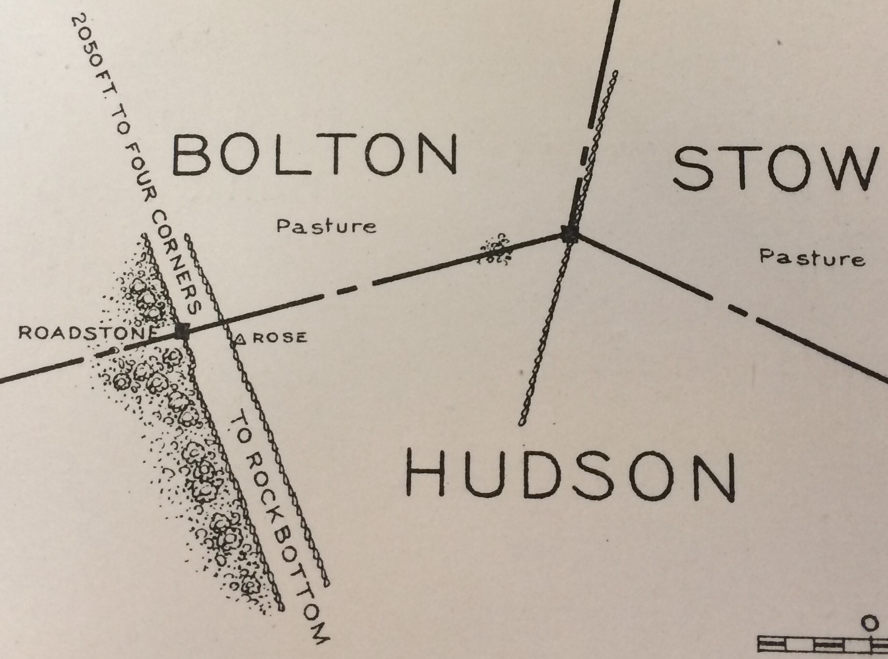
Brigham says Manning Street used to be called Maple Street that’s the same name as its called in Stow is this just a coincidence?
http://hudsonhistoricalsociety.org/pdf/Brigham's_Early_Hudson_History.pdf
Wilber says Samuel Bruce lived at the corner of Cox and Maple (now Manning) 125 years before 1894 gives 1769
I thought Samuel Bruce lived at Century Mill which would be the intersection once the New Road to the Mills was put through in 1700.
Don’t get confussed by the modern names Bolton especially Bolton Center was not where it is now until 1738
We need more information
March 27, 1656 a road was laid out from Lancaster to Sudbury.
The old road is about a third of a mile from the present
residence of Herbert Stratton. It is known as the Woolly or Willy road.
On the north side of this road the distance mentioned from Stratton’s house,
are the ruins of the home of Abiel Bush, who was living there as early as 1690.
Brigham Part 25 — 1894
Hold on 1656 sounds like the date for the Lancaster Concord Road. Are we sure Wilbur didn’t confuse Concord and Sudbury? Or were they possibly the same in the Marlboro/Indian Territory?
Are we now looking for:
1643 Nashaway Trail
1653 Sudbury – Lancaster Road
1656 Sudbury – Lancaster Road
1656 Concord – Lancaster Road
1675/6 King Philips War
1691 Marlboro – Lancaster Road
1700 Marlboro – Lancaster Road
1769 Marlboro – Lancaster/Stow Road
We better check out the library again.
I think they have a plan book that gives all the town boundaries with dates, references and maps
Rondo has not received his doggie drivers license yet.
Lets send Farmer to the Library and the Town Hall
I would go myself but you know how they discriminate against us.
I think we need to focus our research on Abel Bush and Isreal Heald
Bush was a Marlboro Man
Heald a Concord Man
It looks like both came here after King Philips War
What about the Wheelers?
Were they Concord Men?
In 1675 Acton was part of Concord or part of the Wilderness
I was wandering in this wilderness and found a Spooky Stone Chamber I had to duck down to get in and it was really dark Inside
Alright young lady Halloween is over we don’t need anymore of the spooky business Thank You
We’d like to get on with Thanksgiving plans maybe we should think about heading south to see the family.
If you believe the Lamestream Archealogical Explaination that chamber is where Wheeler was storing his Thanksgiving Feast
Is this where the Whitcombs were Storing the Dead Bodies?
Farmer Knows Where the Bodies are Buried around here
I don’t buy the 1791 date but it looks like it might be a Whitcomb thing. Does it have anything to do with the Lime Quarry?
That is some bright white mortar, maybe it came from the Hilldreth Quarry
In Stow they tell the story of “Crazy” Ben Whitcomb sleeping in the tomb.
Maybe we need to connect the dots between the Whitcomb Tombs
I was reading Child’s History of Stow
The Kettles must have survived King Philip and returned to Salem,
She says Isreal Heald bought our farm from James Kettle in 1706
Thanks Assabetee for the lead.
Your grandmother Bettee Whitney was a Harvard Woman by way of Lancaster (same place) her family previously removed of Stow and before that Watertown
She then Married Samuel Bruce and they lived on Maple Street in Lancaster then Bolton then Marlboro then Bolton then Hudson all without moving from their home by
Bruces Pond
Now I’ve confussssed myself
I just checked with the Secretary of the Massachusetts Bay Colony not the Plymouth Colony
To find out when this area was settled.
He says:
Bolton 1682
Hudson 1699
Stow 1681
See The Full List of Towns and Dates
Thank You Secretary Galvin
How can Boxboro be 1680?
Does Secretary Galvin know something we don’t yet?
Petrus
How do you keep all these dates and facts straight?
I read what Secretary of State Galvin said about the settlers
But those dates don’t seem to include people living in the wilderness like the Kettles or Us
Did Kettle Live in the Wilderness or in Lancaster?
We have record of him living in Lancaster because they had records
Was anyone keeping track of those living in the Wilderness?
The Kettles had a good 10 plus years of peace before the “War Whoop and the Tomahawk”
They would have made quite a bit of progress on their 300ac Grant.
Are we to believe that some part of the Original Kettle House remained as incorporated within the no longer extant 194 Maple Street, If not why was this spot better than the one Kettle picked 50 years earlier?
Was this structure situated within the original grant as conveyed from J Kettle to I Heald
Where does the conveyance from Burke to Heald come into play?
That’s not where the monument is
Maybe Rev Clark was right
Abraham Joslin’s Will was probated 1671
We know Kettle still leased the farm in Lancaster at that point, which might mean the 300ac was not ready for habitation by the fairer sex yet
Or “Walnut Swamp” was a lot closer to the center of Lancaster which is how they ended up at the Rowland Garrison
Perhaps it was their Winter Summer Home
I’ve got my eye on you too