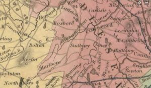
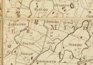
On February 11, 1829, the land of Daniel Stratton of Marlboro was annexed to Bolton
This change does not appear to have effected the Stow-Bolton Line
Nor does it appear to have effected the Marlboro-Bolton Line. Maybe 4 years was not enough time to get the changes to the map maker
Why does Stow have that Tail?


OK so 1833
Looks like just County Lines and County Roads
The second map looks older what is the date?
These maps are both pre Great Road: Meadow Road is still in use on the road to Stow Center and on to Concord we can tell by the dip to the south in Bolton and the turn to the north in what will become Maynard. The New Lancaster Road / White Pond Road is the crossing of the Assabet, Dr Wood’s/Russel’s Bridge (1715). From there on to Rice Tavern and the intersection with the Marlboro-Concord Road inside the Old Army Base
Long Hill Road is not shown on the first map, but it is shown on the second older? map
Is there a place where we can find when county roads were created and discontinued?
110 Rods = 1/3 of a mile t
That’s a long tail.
Maybe that’s so it can swat all the flies from the “Cow Commons”
That’s what I use my tail for
The second Map shows Boxboro
The town of Boxboro was not created until November 4, 1835
But the district of Boxboro was created by Chapter 41 of the Acts of 1782-83
Not sure if that helps any
Why isn’t Maple Street etc. on either of these maps?
Wilber says Samuel Bruce lived here 1769 and Abel Bush before 1690
Is a “Country” road the same as a “County” Road?
Maybe some of these Clerks should take an ESL Course
check this out “Original Bolton – Marlboro Line”
I think this came from the Bolton Library
Does this mean Bolton or Lancaster?
What year is original?
1659
1738
1829
Jasper
Some of these sources need to be vetted using a 21st century standard.
Your Mapmaker assigns the tail to Bolton not Stow
But shows the 1659 Lancaster South East Corner got chopped off as a straight line.
Here’s a Sneak Peak at the Indian Plantation
“The Indian plantation be enlarged to the most westerly bounds of the fence, now standing on the west side of the hill of planting field, called Ockoocangansett, and from thence be extended in a direct north line until they have their full quantity of 6000 acres”
What About Wet Ass Brooke?